The L-Range Family of Models
The
L-Range family of models are tools that simulate ecosystem dynamics at a monthly time-
step at a moderate level of complexity. The tools represent herb, shrub, and tree dynamics for a variety of
layers and pools, such as four soils layers, herbs under shrubs, herbs under trees, leaf carbon, fine root
carbon, and fine branch nitrogen. Spatial surfaces describe the landscape, such as soil attributes, land
cover, and slope. Landscapes are divided into areas that are sufficiently similar so as to have a single set
of parameters describe vegetation dynamics. More than 100 spatial surfaces representing ecosystem attributes
are produced by the tools.
After an application is assessed to ensure it represents dynamics adequately to meet objectives, the tool may
be used in scenario analysis. The tools may be joined with others as well. L-Range has been joined with
agent-based models that represent households at very small spatial scales to all of Kenya. Scenarios may
then be addressed with the tools. Examples include addressing effects of climate change, policy proposals,
livestock stocking, invasive species spread, questions of herbivore access, and herbivore conservation.
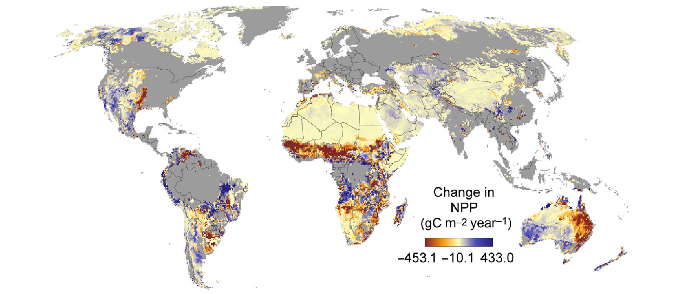
G-Range applies at a global scale and has an application in place that was used in Boone et
al. (2018) at 0.5 degree spatial resolution. Finer resolutions may be used as well.
L-Range may be applied at any resolution to an area, and has been used in areas of a few square kilometers to
all of Africa. The tool is well suited to connect with other tools, yielding a coupled systems model.
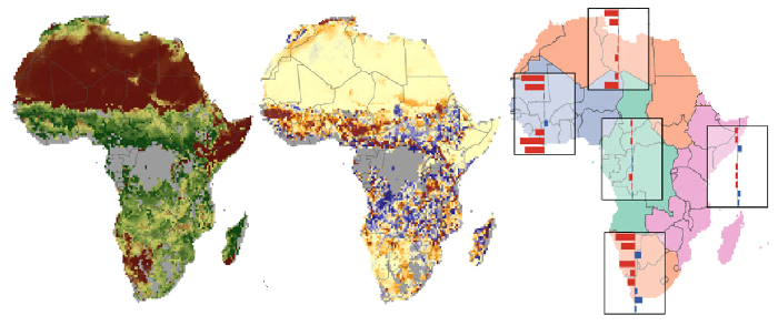
Af_Range is a ready-to-use application of L-Range to all of Africa that continues to be
revised and improved (and is currently under development). The landscape is divided into many homogeneous
units for to allow greater agreement between simulated and observed patterns. Herbivore populations may be
represented in the model, if a user wishes.
Click on a box below to learn more about one of the tools.